South America is a
continent situated in the
western hemisphere and, mostly, the
southern hemisphere, bordered on the west by the
Pacific Ocean and on the north and east by the
Atlantic Ocean;
North America and the
Caribbean Sea lie to the northwest.
As part of the
Americas like North America, South America is named after
Amerigo Vespucci, who was the first European to suggest that the Americas were not the
East Indies, but a
New World unknown to Europeans.
South America has an
area of 17,840,000
km² (6,890,000
sq mi), or almost 3.5% of the
Earth's surface. As of
2005, its
population was estimated at more than 371,000,000. South America ranks fourth in area (after
Asia,
Africa, and North America) and fifth in population (after Asia, Africa,
Europe, and North America).
South America is generally considered a continent forming the southern portion of the
American landmass, south and east of the
Panama Canal transecting the
Isthmus of Panama. Depending on source, South and North America are sometimes considered a single continent or
supercontinent, while constituent
regions are infrequently considered
subcontinents. Geologically, almost all of mainland South America sits on the
South American Plate.
Geopolitically, all of
Panama – including the segment east of the Panama Canal in the isthmus – is often considered a part of North America alone and among the countries of
Central America.
It became attached to North America only recently (geologically speaking) with the formation of the Isthmus of Panama some 3 million years ago, which resulted in the
Great American Interchange. The
Andes, likewise a comparatively young and seismically restless mountain range, run down the western edge of the continent; the land to the east of the Andes is largely tropical
rain forest, the vast
Amazon River basin. The continent also contains drier regions such as
Patagonia and the extremely arid
Atacama desert.
The South American continent also includes various
islands, many of which belong to countries on the continent. Many of the islands of the
Caribbean (or West Indies) – e.g., the Leeward and
Lesser Antilles – sit atop the
Caribbean Plate, a tectonic plate with a diffuse topography. The islands of
Aruba,
Trinidad, and
Tobago sit on the northerly South American
continental shelf. The
Netherlands Antilles and the
federal dependencies of Venezuela lie along the northerly South American
continental slope. Geopolitically, the island states and overseas territories of the Caribbean are generally grouped as a part or subregion of North America.
[1] [2] [3] The South American nations that border the Caribbean Sea – including
Colombia,
Venezuela,
Guyana,
Suriname, and
French Guiana – are also known as
Caribbean South America.
South America contains the world's highest waterfall,
Angel Falls, the largest river (by volume), the
Amazon River, the longest mountain range, the
Andes, the driest desert,
Atacama, the largest rainforest, the
Amazon Rainforest, the highest capital city,
La Paz, Bolivia, the highest comercially navigable lake in the world,
Lake Titicaca, and the world's southernmost town,
Puerto Toro,
Chile.
South America's major natural resources are
copper,
iron ore,
tin, and
oil. The many resources of South America have become useful around the world. However, they often have hindered the development of diversified economies. This has led to major highs and lows in the economy of South American states, often also causing political instability.
South America is home to many interesting and unique species of animals including the
llama,
anaconda,
pirana,
jaguar,
vicuna, and
tapir. The Amazon rainforests possess high
biodiversity, containing a major proportion of the
Earth's
species.
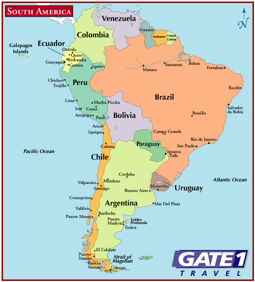
The largest country in South America by far, in both area and population, is
Brazil, followed by
Argentina. Regions in South America include the
Andean States, the
Guianas, the
Southern Cone, and
Eastern South America.